|
|
Chris De Herrera's Windows CE Website |
|---|---|
About |
|
| By Chris De Herrera Copyright 1998-2007 All Rights Reserved A member of the Talksites Family of Websites Windows and
Windows CE are trademarks of
Microsoft All Trademarks are owned |
Windows CE Maps FAQ
By Chris De Herrera,
Copyright 1998, 1999
Version 1.18 Revised 10/6/99
[an error occurred while processing this directive]
Introduction
There are a variety of map software applications available for Windows CE. This article lists them and describes their features.
You can download topographical maps to you Windows
CE Handheld PC. It supports backcountry details and works with
your GPS via a serial cable (not included). GPS support for Topo USA only
works with Windows CE 2.0 devices.

HandMap offers their standard version for free which includes the ability to download US maps. It includes features such as getting the nearest intersection, showing what type of roads are there (ie: freeway, highway, street, railroad track etc.). You can also define your route and it will display text based instructions for each step of the way. In the Deluxe version you can layer maps over each other and the Pro version provides GPS capabilities.
LaserMap offers GPS integration with a moving map with detailed street information. The Moscow Federation maps are provided and maps of other countries are available on request.
MapPad is designed to keep track of assets (power poles, street lights, buildings, mineral exploration, road repair etc) and enter comments and a sketch on a GPS coordinated map. It displays a moving cross hair on the map based on the location of the GPS. It also supports layers so you can add a map of your specific assets right on top of a regular map. It operates on a H/PC and P/PC.
Microsoft MapPoint 2000 is a desktop mapping application that integrates with Office 97. It is designed to allow the user to export maps for the Handheld PC and Palm-size PC.
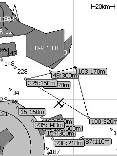
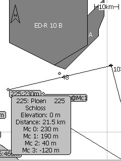
Palm-Nav from Cambridge Aero Instruments offers maps that are designed to be used for Pilots. Six pilots are flying at Bavaria-Glide with a new device for flight information display. This includes Class C and D control zones, prohibited airspace and Glide Sectors. Based on positive response from these pilots, Cambridge announces commercial availability of the system for the 1999 gliding season. The Cambridge Palm-NAV system includes the GPS-NAV Secure Flight Recorder, a database of European Special Use Airspace and the Application Software. The display (image) for the system is a Windows CE based Palm-size PC with a 320 x 240 pixel touch sensitive LCD screen with 4-level gray scale. The Palm-NAV graphic display is a moving map of restricted airspace, turnpoints and the competition task, including the start line. Details of each map feature are accessible by tapping on the name or number. Zoom and Pan functions are also supported by the touch screen.
Pocket Map Blast offers the ability for ANY Windows CE user to download a picture of the map location of their choice to their H/PC, H/PC Pro or P/PC. You can specify the size of the maps before you download them. This is available for almost any country in the world, including the US, Canada, Europe, etc. I recommend that users that want free maps to check it out!
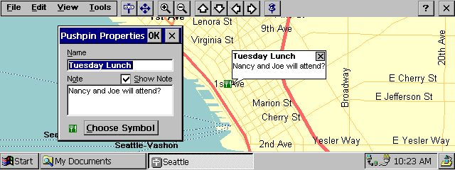
Pocket Streets provides standard maps. It is available for free for selected cities and it's provided on the Windows CE Services CD. The latest version supports color maps. Other cities can be added by purchasing Expedia Streets 98. It is compatible with the H/PC, H/PC Pro, and P/PC. The maps are available for the US only. An add-on called Streets 98 Exporter can assist you with exporting out a series of maps for a specific area much easier than using Expedia Streets 98 by itself.
Pocket Streets provides standard maps. It is available for free for selected cities and it's provided as a download from Microsoft's Website. Other cities can be added by purchasing Streets & Trips 2000 and Autoroute Express 2000.. It is compatible with the H/PC, H/PC Pro, and P/PC including the Wyvern and Jornada 820. Note: You must remove any older version of Pocket Streets before installing 3.0. Also, maps from prior versions are not compatible with 3.0.
RoadPilot CE provides maps of Singapore. It is the first Windows CE mapping application to use Geographic Information System (GIS) based viewing. The map is GPS surveyed and includes the details on the buildings as well as streets.
Route Planner (Replaced by RoutePlanner Millenium)

Route Planner is an International map software application. It provides route planning from one location to another with up to 4 stopovers. You can purchase RoutePlanner for North America which covers the United States, Canada and Mexico or RoutePlanner Europe which covers Eastern Europe, Western Europe as well as the United Kingdom and Greece. Maps are compatible with the H/PC only.
Route Planner Millennium is a sophisticated Road Map and Route Planning application. It can display the major road networks on many different scales, and show you the best way to get from A to B. It is available for P/PC, H/PC and H/PC pro. You can attach a Global Positioning System, which will track your position on the map. The North America version covers the United States, Canada and Mexico. The Europe version covers all Eastern and Western European countries including the United Kingdom, France, Germany, Italy, Spain, Portugal, Austria, Switzerland, Belgium, and the Netherlands.

Solus Basic/Pro provides details about local streets, highways and other points of interest. It also includes door to door routing. This application does not support colors. Solus Pro supports using a GPS with Windows CE 2.0 devices. GPS support is not yet available for Windows CE 2.11 devices. You can download Solus Basic for free at ftp://ftp.releasesoft.com/delorme/solusbce.exe
StreetFinder allows you to look up specific addresses on their maps. It also includes the Mobile Travel Guide with information on resturants and lodging.
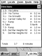
Directions Example
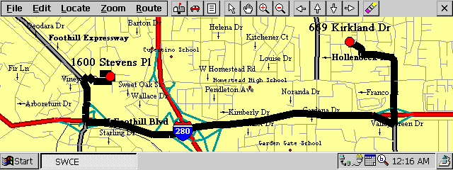
Routing Example
StreetWizard provides street maps as well as automatic routing with text right/left turn directions for any destination. Street Wizard is compatible with the H/PC, H/PC Pro and soon the P/PC. These maps are available for the US streets and aviators. You can also inport your own JPEG maps as well with the Geocoder application.
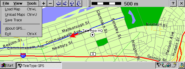
TeleType GPS provides street maps with GPS positioning. It's great for finding your way when your lost. It is compatible with the H/PC, H/PC Pro and P/PC. The product comes with high resolution vector maps for the U.S. and offers a worldwide maps option. You can also import maps from the Internet. Also, Teletype offers maps for Pilots which include critical information about airports and airspace restrictions, etc.
TripMaker allows you to plan a trip and then download it to your Windows CE PC Companion. It also includes the Mobile Travel Guide with information on restaurants and lodging.
[an error occurred while processing this directive]


